 |

 |
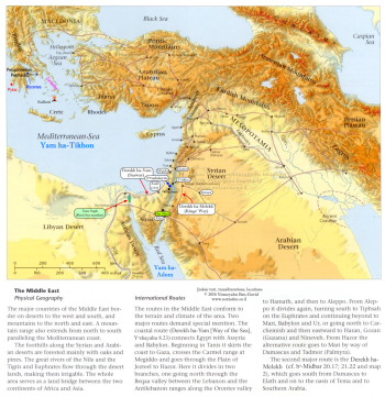
From Mi•tzᵊraꞋyim and Mi•dᵊbârꞋ Sin•aiꞋ, there were only two caravan routes through the deserts and mountains northward into the Levant (Kᵊna•anꞋ) —
DërꞋëkh ha-Yâm, along the coast of Yâm ha-Ti•khōnꞋ (the Mediterranean Sea), and
DërꞋëkh ha-MëlꞋëkh, along the east bank of Nᵊhar ha-Ya•rᵊd•einꞋ (in present-day Jordan).
Passage from Mi•tzᵊraꞋyim through DërꞋëkh ha-Yâm, in the area around the crook turning north, was controlled and taxed by the Pᵊli•shᵊt•inꞋ. Road taxes and caravansary income from trader caravans represented a significant part of the Pᵊli•shᵊt•inꞋ economy that they would not be willing to jeopardize; and they were too powerful for fledgling Israel to challenge militarily. So marching Israel's military through DërꞋëkh ha-Yâm was never viable.
 |
This left DërꞋëkh ha-mëlꞋëkh — caravanning up the east bank of Nᵊhar ha-Ya•rᵊd•einꞋ, from where they could cross into Kᵊna•anꞋ at Yᵊri•khoꞋ.
However, from the region of al-Arish in the northeastern Sin•aiꞋ where Israel was, they could only reach DërꞋëkh ha-mëlꞋëkh either by going south through difficult terrain, via Har Sin•aiꞋ, to merge with DërꞋëkh ha-mëlꞋëkh at Eil•atꞋ or, more directly, by negotiating peaceful passage through the territory of — A•mâ•leiqꞋ. This was Mōsh•ëhꞋ's "Plan A".
 Wadi Ain al-Qudeirat 350x236.jpg) |
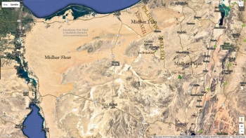
Israel was growing its military and training for war in Mi•dᵊbârꞋ Tzin, which is located in the northeast Sin•aiꞋ, then abutting the Pᵊli•shᵊt•inꞋ, to the northwest and A•mâ•leiqꞋ to the north and east, in today's Israeli NëgꞋëv.
Israel's objective was to recover their promised native lands, which had been occupied by Kᵊna•an•iꞋ tribes to the north – on the far side – of A•mâ•leiqꞋ, in the interior of Kᵊna•anꞋ adjacent to Mi•dᵊbârꞋ Pâ•rânꞋ.
Viewing Israel's military training in plain, ominous and threatening, view in front of them, the next valley over, however, the tribe of A•mâ•leiqꞋ increasingly worried that the Israeli build-up was aimed at maturing into an attack, that Israel secretly intended to conquer them, taking their land as a base to continue straight north into the Israeli homeland.
Consequently, quite opposite to negotiating safe passage for Israel through their territory to access DërꞋëkh ha-mëlꞋëkh, A•mâ•leiqꞋ launched what they regarded as a preeminent attack against Israel at Rᵊphid•imꞋ.![]()
 sekhem (r) 0350x297.jpg) |
Then Mōsh•ëhꞋ ordered Yᵊho•shuꞋa, "Put together a select unit to stop A•mâ•leiqꞋ's advance. Tomorrow, I'll stand on top of the hill, where I can see all that's going on and all of the troops can see me, with the scepter of the ël•ōh•imꞋ in my hand to signal maneuvers."
So Yᵊho•shuꞋa went out with his hand-picked unit as Mōsh•ëhꞋ had directed and engaged the forces of A•mâ•leiqꞋ. Meanwhile, Mōsh•ëhꞋ, A•ha•ronꞋ and Khūr went to the summit of a hill overlooking the battle.![]()
As the war raged, Mōsh•ëhꞋ monitored the battle from the summit above the valley where he could see all troop movements, both Yi•sᵊr•â•eilꞋ and A•mâ•leiqꞋ, for a great distance – and, critically, his field officers could see him.
Stationing himself at such a vantage point enabled Mōsh•ëhꞋ to monitor the entire battlefield; quickly identifying any enemy ambush, instantly seeing from afar any possible approaching reinforcement forces – and instantly transmitting early warning to his field commanders engaged in combat with the A•mâ•leiqꞋ forces in the valley below. This afforded Yi•sᵊr•â•eilꞋ's field officers constant, up-to-the-second battlefield awareness of the enemy's tactics, in the heat of battle; and immediate tactical orders from the former Egyptian Pharaonic Prince and General – Mōsh•ëhꞋ.
 500x330.jpg) |
His field officers on the battlefield then gave orders to their sho•phârꞋ-blowers, to blow the appropriate blasts signalling the appropriate intelligence and battle orders to Yi•sᵊr•â•eilꞋ forces, giving them the advantage to remain on the offensive – so that Yi•sᵊr•â•eilꞋ prevailed.
But, when Mōsh•ëhꞋ's arms became tired and his legs grew tired of standing (from where he could see afar and be seen from afar), he could no longer signal enemy troop movements nor communicate tactical orders to his field commanders – and A•mâ•leiqꞋ began to prevail.
Thinking quickly, A•ha•ronꞋ and Khūr![]() rolled a large stone in place for Mōsh•ëhꞋ to sit atop. Then they propped-up and manipulated his arms and scepter, as he directed. As a result, Mōsh•ëhꞋ's signals to the troops below were unfailing until the sun went down and, by their military proficiency,
rolled a large stone in place for Mōsh•ëhꞋ to sit atop. Then they propped-up and manipulated his arms and scepter, as he directed. As a result, Mōsh•ëhꞋ's signals to the troops below were unfailing until the sun went down and, by their military proficiency,![]() Yᵊho•shuꞋa repulsed the attack by A•mâ•leiqꞋ and his am.
Yᵊho•shuꞋa repulsed the attack by A•mâ•leiqꞋ and his am.
 0350x263.jpg) |
“Write this remembrance in a book and make it a priority in the ears of Yᵊho•shuꞋa because I'm going to utterly blot-out the memory of A•mâ•leiqꞋ from under the heavens.”
So Mōsh•ëhꞋ constructed a mi•zᵊbeiꞋakh and called it "é‑‑ä ðÄñÌÄé",![]() saying, "As the Yâd is on the [qërꞋën] Keis-éÈäÌ: so Mi•lᵊkhâm•âhꞋ la-SheimꞋ shall rage from generation to generation."
saying, "As the Yâd is on the [qërꞋën] Keis-éÈäÌ: so Mi•lᵊkhâm•âhꞋ la-SheimꞋ shall rage from generation to generation."

Optional parental preparation:
What is the Levant?
Who was "Yᵊho•shuꞋa (Bën-Nun)"?
Who was "A•mâ•leiqꞋ"?
What is a nation's "economy"?
Qâ•deishꞋ Bar•neiꞋa — Despite digging down to virgin soil in a number of spots, neither humanities-trained archeologists sporting Arts degrees, nor scientists relying on the early archeologists' work, have found the first shard of Israel & Southern Levant Middle Bronze Age 2c late *c BCE 17th century to early BCE 16th century; i.e. c BCE 1625-1575) evidence at their favored site: Tel al-Qudeirat – or (≈20km to the south) Ein Qedeis. Both are likely too far southeast. The Israelis pulled-up short of crossing this boundary into Mi•dᵊbârꞋ Pâ•rânꞋ – territory long settled and held before Israel's arrival – by A•mâ•leiqꞋ.
While the site hasn't yet been completely excavated, the absolute lack of evidence of Israeli presence, having reached virgin earth in places, strongly suggests that they've been looking in (many) wrong places. While it may prove impossible to distinguish Israeli camps from local nomadic tribes, the correct location of Qâ•deishꞋ Bar•neiꞋa will yield some evidence of human occupation from that time period. From the most basic security strategy, the sites proposed by scholars would have placed Israel in a valley (Ain al-Qudeirat) beneath A•mâ•leiqꞋ forces on the mountaintops overlooking the valley – a "no man's land" (perhaps corroborated by the very lack of evidence of occupation during the Middle Bronze period) easy prey for A•mâ•leiqꞋ that would have been the end of Israel.
Therefore, it seems more likely that the Israelis bivouacked at a safer distance from A•mâ•leiqꞋ; to the northwest, back toward el-Arish.
Today's roads often follow the same topography as ancient routes. Bivouacking a million people![]() for 40 years no closer than the next valley to the northwest (5 km/3 mi; cf. photo) would place their south-easternmost point, closest to A•mâ•leiqꞋ, in the vicinity of the intersection of the main north-south artery, the Al-Qoseama - Rafah - Taba road, with the main east-west artery, the Al-Qoseama - Al-Hasna road. This location, in the vicinity of modern al-Qosimah, would afford the Israeli forces to post observers on the mountaintops overlooking Ain al-Qudeirat from the west. The valley itself was probably controlled and inhabited by A•mâ•leiqꞋ, who would have posted observers on the east looking back at them across the valley. The excavations in the valley evidence a border fortress, one of a line of similar fortresses, from later times, suggesting this valley was favorable as a natural border from earliest times.
for 40 years no closer than the next valley to the northwest (5 km/3 mi; cf. photo) would place their south-easternmost point, closest to A•mâ•leiqꞋ, in the vicinity of the intersection of the main north-south artery, the Al-Qoseama - Rafah - Taba road, with the main east-west artery, the Al-Qoseama - Al-Hasna road. This location, in the vicinity of modern al-Qosimah, would afford the Israeli forces to post observers on the mountaintops overlooking Ain al-Qudeirat from the west. The valley itself was probably controlled and inhabited by A•mâ•leiqꞋ, who would have posted observers on the east looking back at them across the valley. The excavations in the valley evidence a border fortress, one of a line of similar fortresses, from later times, suggesting this valley was favorable as a natural border from earliest times. ![]()
Questions you might anticipate that your child might raise and be prepared to discuss:
What is a "crook" in a path?
What is a road tax?
What does "imminent" mean?
What were trader caravans? (Ancient version of trucking, rail and air transport of goods and people)
What was a "caravansary"? (an ancient hotel/motel)
What does "significant" mean?
What does it mean to "jeopardize" (or risk) something?
What is an "east bank" versus "west bank" of a stream, river or lake?
What is "terrain"?
What does "merge" mean?
What is "Plan A"? (Plan B, etc.)
What does "abut" mean?
What does "repulse" mean?
What is a "priority"?
How does one "blot" something?
What is a "generation"?
What does "ominous" mean?
What does the verb "mature" mean? The noun?
What does "opposite" mean?
What does "hand-picked" mean?
What does "prevail" mean?
![]()
 |
 |